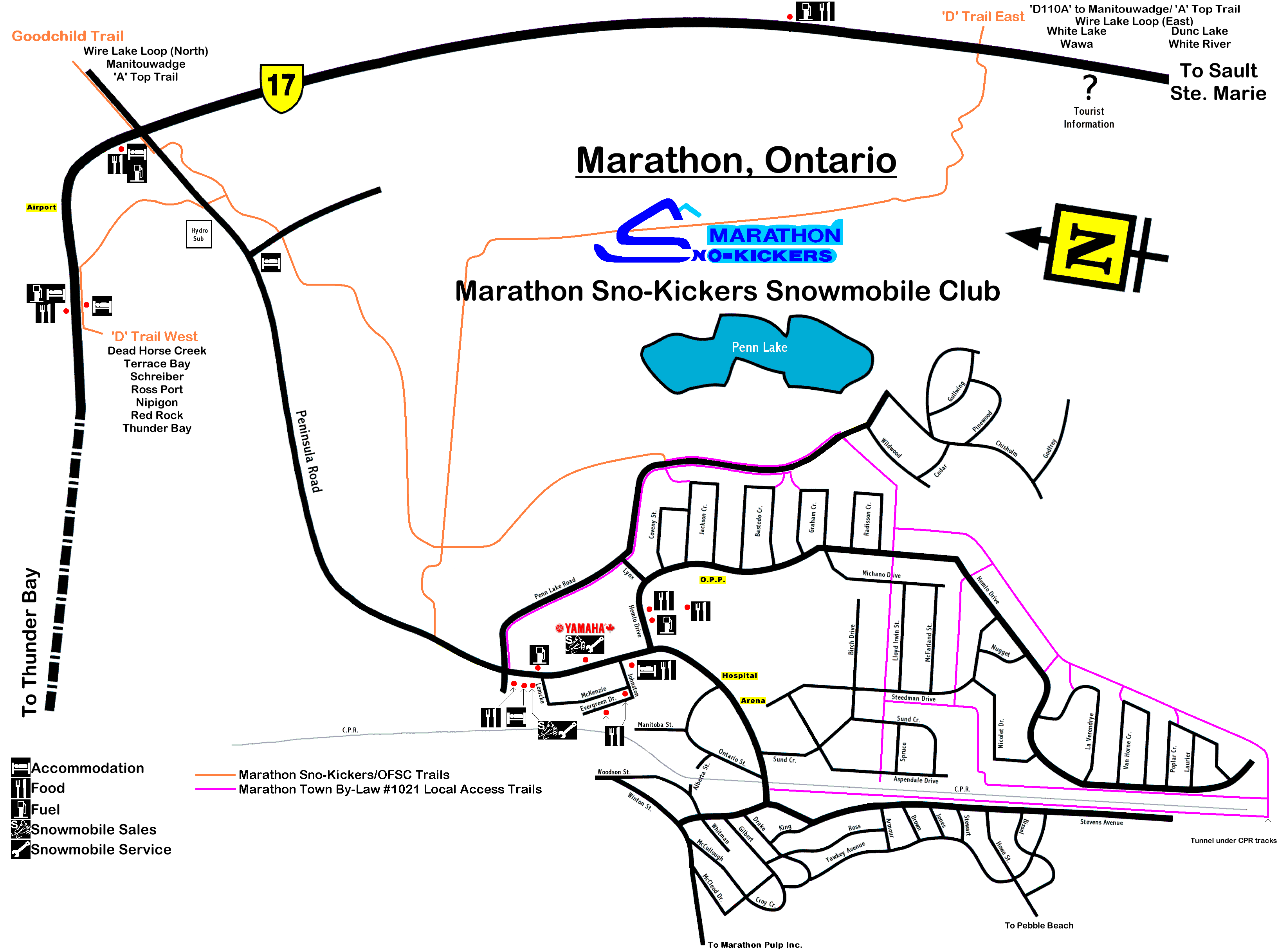
The local map shows the trail system in the town of Marathon, including the town by-law access routes. The OFSC/Sno-Kickers trail is shown in orange. Town by-law local access trails are shown in purple. The map is 3288 x 2433 pixels. File size is 338,303 bytes. Local services and accommodations are shown on the map.
The following maps were made with the use of OziExplorer and OziExplorer3D.
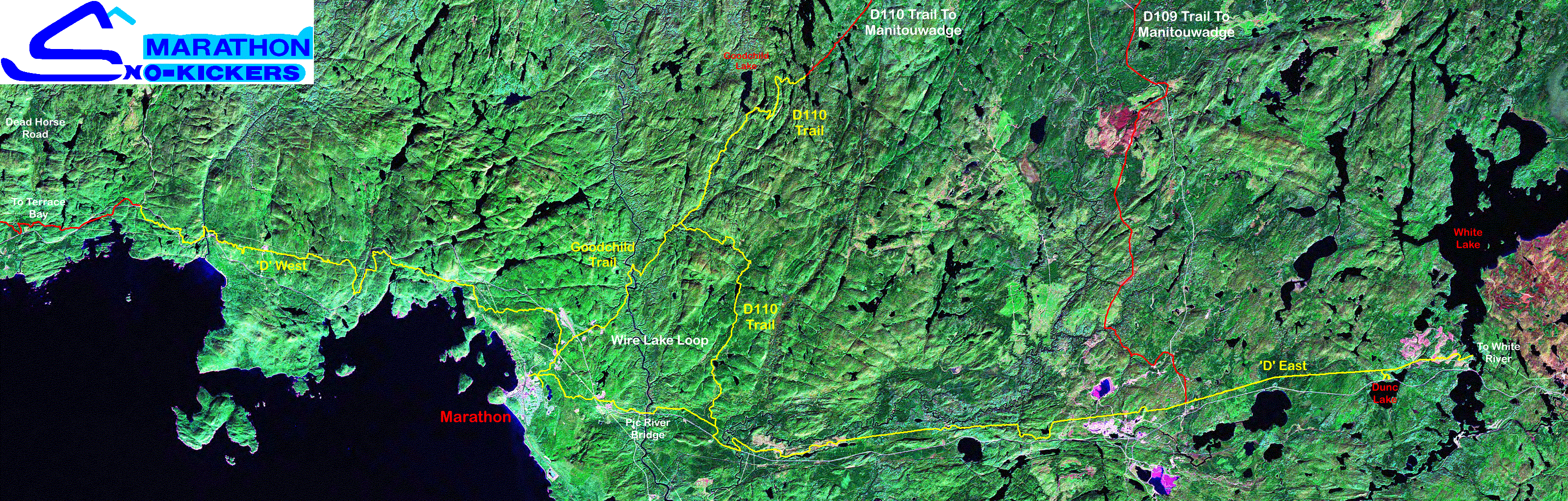
Click on the image below to see a map of the Marathon Sno-Kickers trail system on a composite satellite image. The full map is 3197x1022pixels. File size is 2,016,717 bytes. Each pixel is 14.25 Meters. Marathon's trails are marked in yellow. Neighboring club trails are in red. D109 trail added for the 2006 season.
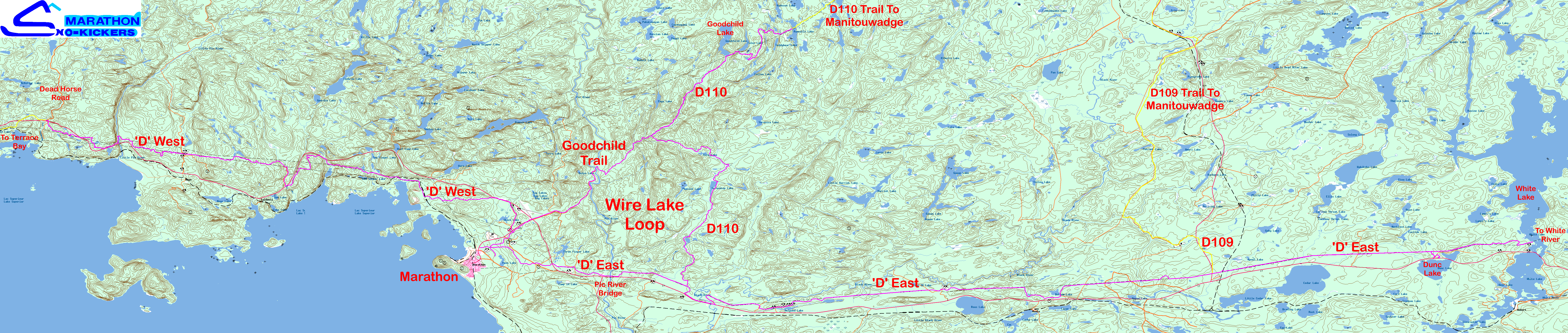
The following map shows Marathon's trails on a 50k Topographic map. Click on the image to get the full map. The full map is 7,107x1,511 pixels. File size is 1,417,460 bytes. Each pixel is 11.20 Meters. Marathon's trails are in this color. Neighboring club trails are in yellow. Part of the D109 trail added for the 2006 season.
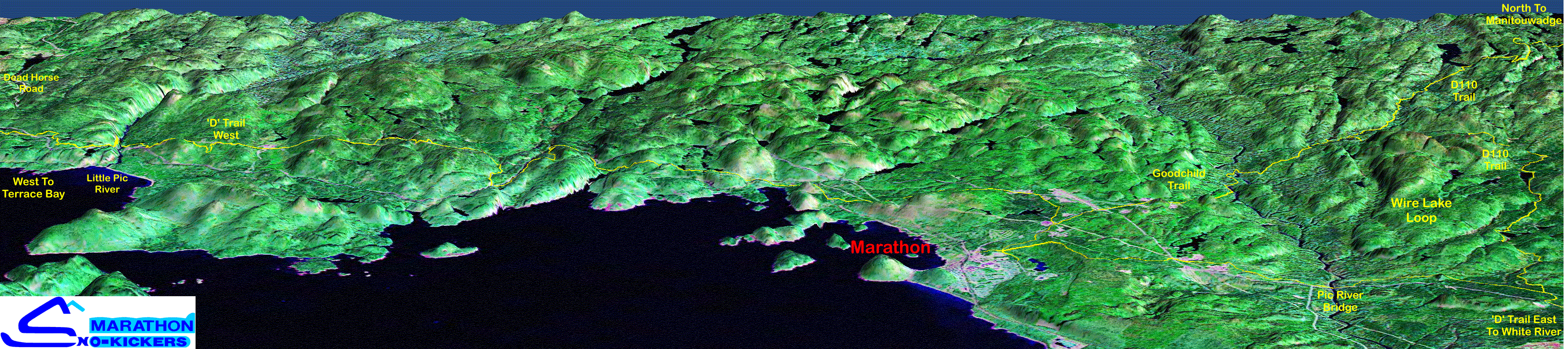
The following map is a 3D rendering of the west, central, and north portions of the Marathon Sno-Kicker's trail system. Click on the image to get the full map. The full map is 3,201x714 pixels. File size is 1,194,229 bytes. The map was reduced to 256 colors, otherwise the file size would be 5.6MB. This map shows the OFSC Top 'D' trail west of Marathon to Dead Horse Road, the D110A trail north to Runnalls Lake, the Goodchild Trail, and the OFSC Top 'D' trail to the east of Marathon a little past the Black River. The trails are shown in yellow. Updated for the 2006 season.
Wire Lake Loop: The triangle formed by the OFSC Top 'D' trail east of Marathon, D110A trail north, and Goodchild Trail back to Marathon makes for an afternoon ride lasting about two hours.
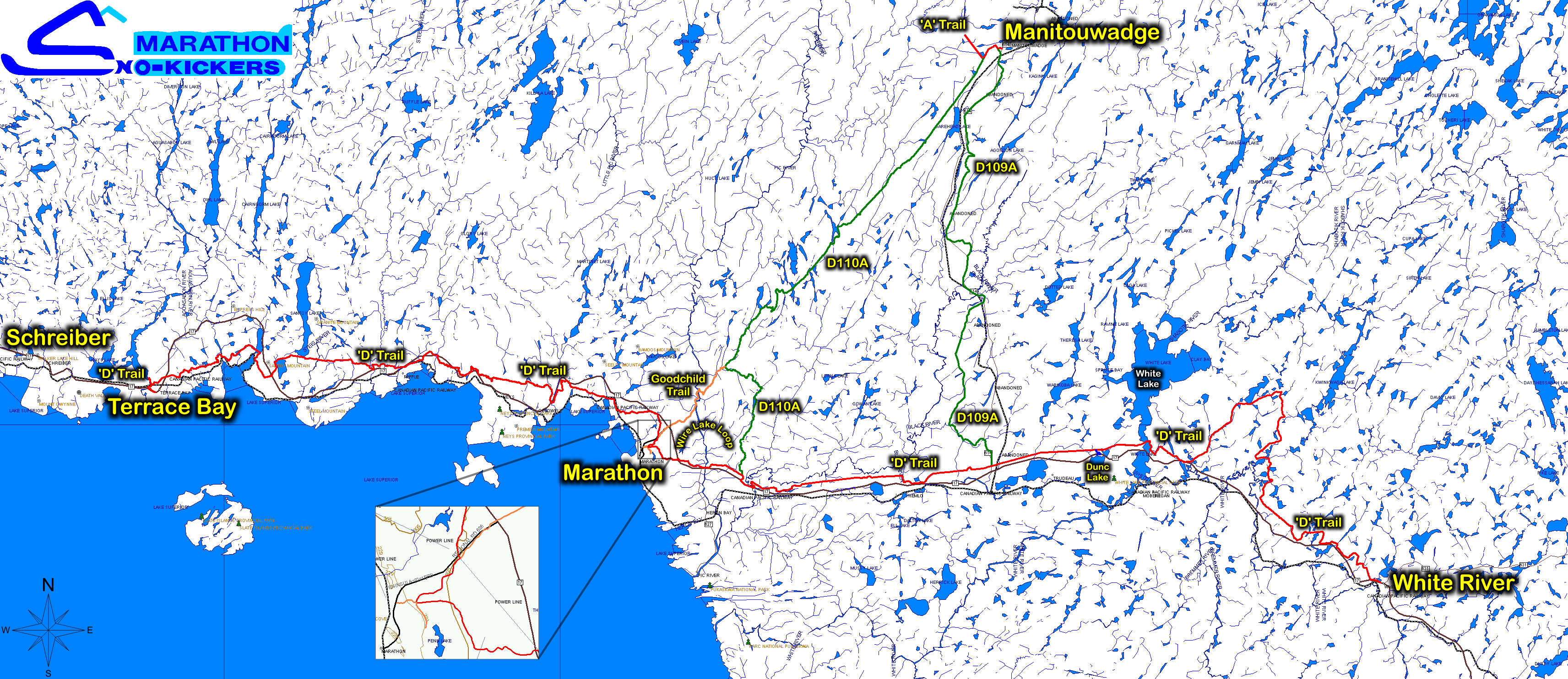
The next two maps cover the trails from Terrace Bay west of Marathon to White River to the east of Marathon, and Manitouwadge to the North East of Marathon. Click on the map image to get the full map. It is 3,425x1,484 pixels and weights in at 844,592 bytes. This map last updated September 2006.
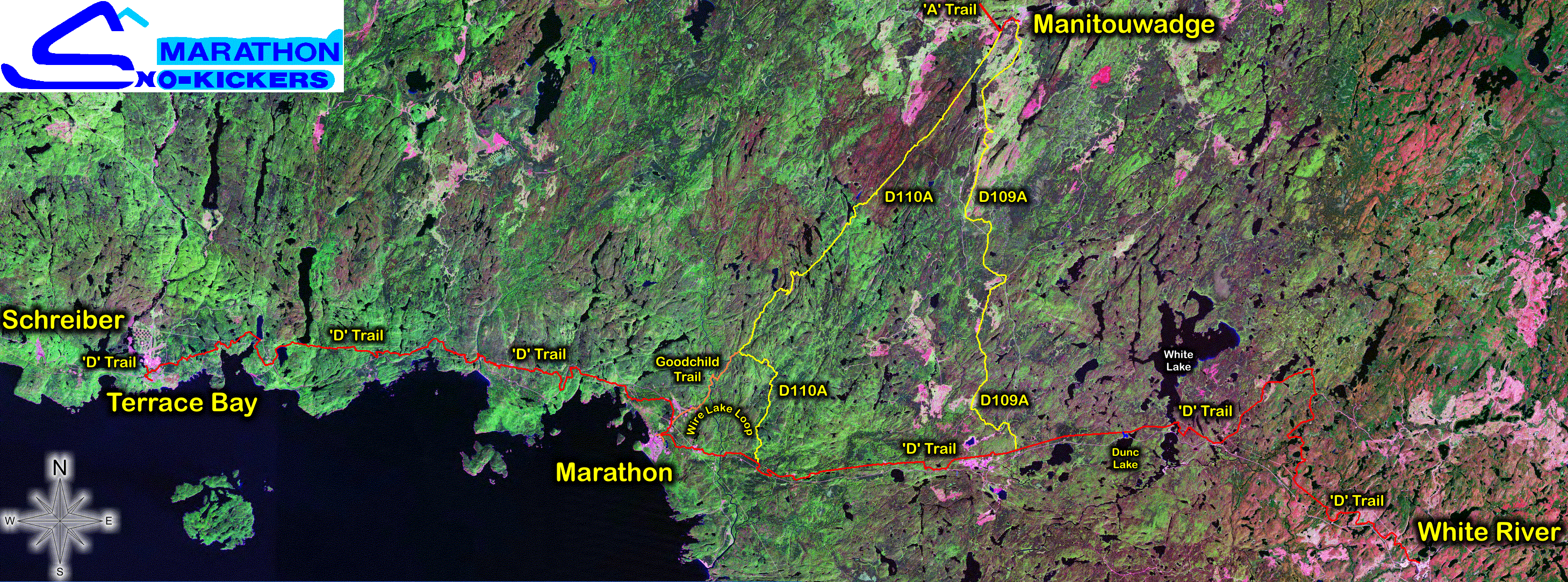
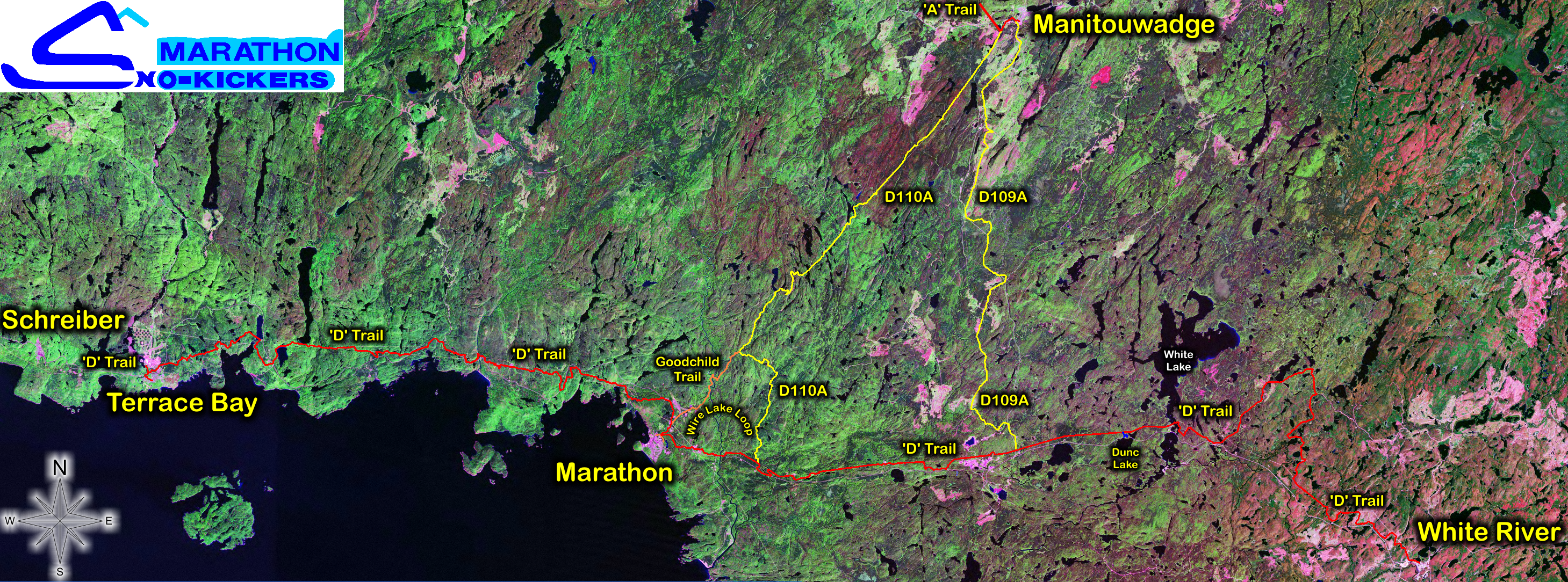
This next image covers the same trails as above, but is on a satellite image of the area. Click on the map image to get the full map. It is 2,918x1,084 pixels and weights in at 1,796,911 bytes. The image has been reduced to 256 colors. Here is the 24 bit version of the image below - over 8M bytes. This map last updated April 2006.
An old interactive map is still available to get more information on some of the services available in the Marathon area. Please keep in mind some of this information is very out of date. The jpg file is 1644 x 1217. File size is 172,991 bytes. Watch the Status Bar at the bottom of your web viewer - click on an area for the names and telephone numbers of the businesses.
Have a GPS receiver? The marker page has co-ordinates for various spots on the Marathon Sno-Kickers trail system.
If you have trouble viewing the map images with your web browser, download the images to your hard drive and view offline with an image viewing program, such as IrfanView.
The OFSC's web site is the official site for OFSC trail status. The North Of Superior Snowmobile Association (N.O.S.S.A.) web site also has the current OFSC District 16 trail status. These are the only sites that can be trusted to be accurate and up to date. Treat all other sources of information (faxes, other web sites, etc.) as being suspicious. If there are questions about trail status, call N.O.S.S.A. at 1-800-526-7522.
|
Wherever possible, the OFSC's TOP Trails are land routes with few ice crossings, but occasionally terrain and geography dictate that the trail crosses a frozen body of water. When it is necessary to ride on ice, always follow the marked trail and stay on the machine-packed surface. Do not stop on ice or wander off the trail. Remember that ice conditions are susceptible to temperature fluctuations during the winter that can weaken ice. Always ask before riding on unfamiliar ice or where there is no obvious main trail. Wearing a buoyant snowmobile suit is highly recommended. If you don't know, don't go. You are crossing at your own risk. |
Trail Info |
||
| Buy Your Permit |
Last updated 20 October 2007
